
Assessment of the Forest Resource
R Smith
Assessment is the act of making a judgement or deciding the amount, value, quantity or importance of a resource.
"Increment blocks have been established during the year in a number of the State plantations. These will be measured annually or biennially as experience warrants it. It is intended to establish more and complete the series during ensuing year."
Source: 1926/27 FCV Annual Report
"Permanent sample plots for the purpose of increment measurement were established in red gum, box-ironbark, stringybark, and mountain forest types, and first measurements recorded. Existing sample plots were also remeasured."
Source: 1929/30 FCV Annual Report
For many young foresters, starting out on their career by joining the Assessment Branch/Section for a few years was regarded as a Rite of Passage, an early stage in their career whereby they gained experience in exploring and walking through the often unmapped and trackless bush, marking a transition to a different and more permanent stage of their career.
In its basic form, Forest Assessment involves the mapping, classification and measurement of the trees and other vegetation in a forest.
In the early history of the Forests Commission, its first Annual Report for the year 1919-1920 stated that:
“The introduction of full systematic management will of necessity be a somewhat slow process owing to the limited staff at present available, and the great difficulty of obtaining trained or qualified men to augment it”.
The first Handbook of Forestry in Victoria published in 1928 stated that:
“It is imperative that surveys of the forest resources be made, and work in this direction has been proceeding steadily. At present two staff surveyors with assistants are constantly employed to carry out the demarcation of forest boundaries, subdivisional, topographic and contour surveys and general survey work. In conjunction with subdivisional work, assessment and systematic valuation of the timber resources are being developed with a view to the introduction of working plan control. The onus of instituting such control is imposed on the Commission by the Forests Act 1918, and since its inception the Commission has made it its business to collect and co-ordinate the preliminary data for the preparation of the actual formal working plans”.
It was later realized however that these surveyors had no specialized knowledge for forest assessment. The nucleus of a new Forest Assessment Branch was formed by the employment of three specially trained European foresters from Norway - Bjarne Dahl, Kristian Drangsholt and Bernard Johannessen.
The timeline for Forest Assessment can be summarised as follows:
1928 – 1948
Each of these qualified foresters from Norway had a chainman and an axeman as their assistants. Early work starting in the Rubicon and Royston forests consisted initially of a baseline survey followed by transects 5 chain apart using tape, chain, compass. Abney level, and Aneroid barometer with 1 chain wide strips in which plots were measured to record species, height, diameter and condition of trees to calculate volume of timber. This early work by these Norwegian foresters initially being based at places like Taggerty and Marysville eventually extended across most of the foothill forests of the State with transects or strips then being placed further apart at 20 chain intervals giving a 5% sample of the assessment block.
1948 – 1953
Forest Assessor- Jack M Fitzpatrick
These strip assessments continued across the State, with forest mapping and classification carried out using interpretation of aerial photography undertaken by the RAAF. Assessments were generally in remote locations with access by 4WD tracks, with staff based in temporary camps under canvas tents. Some assessment teams were also based in rented houses and also huts in road construction camps.
And later on, assessment teams comprising 2 to 3 foresters and 3 to 4 chainmen camped in the mountain forests often in grassy clearings in high elevation snow gum woodland. And at other times assessment teams were camped in caravans in more accessible parts of the forests.
1954 – 1970
Forest Assessor - Duke William Murray Paine
This period marked the transition from strip assessments mainly in mixed species forest to include ash type forests and conifer plantations employing several innovative approaches with a focus on the use of computer programming for volume calculation from sample plots for both sawlog and pulpwood resources. In 1964 the Continuous Forest Inventory (CFI) system for measuring periodic growth, commencing initially in the Wombat forest, then on to Mt Cole, Barmah and conifer plantations. This innovative form of assessment involving periodic measurements of growth and decay provided a rational basis for calculating the annual harvest from the forest
This period also saw the introduction of both sawlog and pulpwood resource assessment in the higher elevation mixed species and ash type forests such as Errinundra Plateau involving the use of remote sensing, starting with aerial photographs to stratify forest types and volume classes as a basis for sample plot measurements followed by double sampling using felling plots to adjust the plot estimates. This phase also involved the more intensive use of computer programming, data processing, information systems and computer simulation.
1970 -1973
Forest Assessor - Arthur Walter Frederick Webb
This period involved the more widespread use of Remote Sensing including the use of 70mm small format aerial photography for mapping pine plantations, coloured aerial project photographs for mapping and assessment of both ash regrowth and higher elevation mountain forests and later the use of satellite imagery starting with Earth Resources Technology Satellites (ERTS) and then followed by Landsat imagery by NASA.
1973 – 1975
Forest Assessor – John Ross May
As well as continuing the program of softwood plantation and ash regrowth mapping, work continued in intensive measurements of sample plots in stratified volume classes for hardwood sawlog and pulpwood resources. Computer programs such as Forest Resources and Yield Regulation Systems (FRIYR) were also initiated during this stage of assessment. This period also involved the mapping and assessment of both vegetation and scenic resources in areas such as Macedon, Baw Baw and parts of East Gippsland such as Ellery Block.
1975 – 1985
Forest Assessor – Roger Barton Smith
Unlike many newly graduated foresters who spent the early part of their careers and worked in Assessment for only a couple of years, I remained in the Assessment Branch for over 20 years following a short period in the Biological Survey Branch and later as assistant forester in the Myrtleford District.
The duties of the Forest Assessor during this period were to “manage the Resource Assessment Section to provide policy advice and specialist services in timber assessment, mathematical modelling and growth simulation, vegetation survey, remote sensing including air-photo interpretation and digital analysis, geographic information systems, maintenance of appropriate data bases and provision of advice on present and future timber availability and changes to vegetation community structure”.
The continued collection of forest resources data required ongoing assessments and updating of previous surveys. A great deal of research was undertaken to apply the development of mathematical formulae defining height and diameter growth for the different tree species for a range of stand conditions including site quality and stand density. These growth models were incorporated into computer-based systems for simulating future growth and yield of the major forest types.
The collection of this data over several decades provide reliable and comprehensive data for the calculation of sustainable yields for submissions to the Timber Industry Inquiry and development of the State Governments Timber Industry Strategy in 1986.
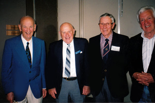
Forest Assessors Four (l to r) - Murray Paine, Arthur Webb, Ross May and Roger Smith at the VSF Centenary Celebration
October 2010
Source: R Smith