
- Details
Understanding the Government’s Century in Plantations
The Government’s more than a century in plantations included many achievements, as well as a number of disappointments and shortcomings. Overall the government’s plantation story was significantly successful.
There were many successes including:
- Early statement and consistent affirmation of a policy of establishing plantations. Initially the goals were to rehabilitate land cleared in the 1850’s gold rushes, provide timber and avoid cost and unreliability of imported timber, generate revenue and create jobs through local sawmills. Commercial financial returns became a more important objective following increased investment with the plantations expansion program.
- A record of achieving planting targets which aimed to meet Victoria’s future timber needs.
- There were significant advances in technology, equipment and practices resulting from effective research and development.
- There were a number of successful, energetic personalities that overcome many challenges.
There were many challenges, the most significant of which was growing opposition in the 1970’s and increasing in the 1980’s. At different times environmental activists, affected local communities and farmers opposed different aspects of plantations for reasons including use of chemicals particularly aerial application, adverse environmental effects, clearing of native forests for plantations, use of purchased farmland for plantations and use of public money in an enterprise which was not providing a satisfactory financial return.
With the benefit of hindsight the questioning and opposition from people outside government needs to be evaluated in the context of changing times. Increasing questioning and opposition to all manner of policies and actions from the late 1960’s was considered a positive change by some and it was occurring at the time in other states as well as in North America and Europe. On the positive side there was commendation from some external parties on environmental standards, early move to cease clearing native forests and the Government’s use of an independent body to review and recommend areas for plantation expansion using a conservation lens. The attractive sale price for the plantations partly ameliorated the earlier poor financial performance.
The chronology listed below provides a snapshot of the events that shaped the government’s plantations century.
The listing in the manner presented necessarily simplifies the story. One might incorrectly conclude that a clear, coherent and consistent pathway was set at an early time to achieve the goal of establishing a well-managed, highly productive and extensive plantation estate for the benefit of Victorians. This is not so and the realty is complex and nuanced. Assembling the many inter-related chapters on the website over time will provide interesting insights into the plantation story.
Listing the significant events does not adequately convey the circumstances and the many influences on government plantation decisions. In many situations there had been a prior build-up period to garner support for a particular position before government actions. Government decisions mostly followed, rather led, public positions. Some of the circumstances and influences included:
- The merits of a policy or position
- Public support or opposition
- Lobbying and cajoling members of parliament by influential “insiders”
- Broader public and/or local affected community support or opposition
- Government willingness, financial capacity and whether the government considered there was political advantage at the time
- Larger scale impact on local communities as the program expanded to purchased private land combined with changing community expectations over time
The Plantation Story
The plantation story can be seen in four sequential periods, as follows:
- 1888-1959 - low level activity. Only a small proportion of the total plantings occurred over the first seven decades. There was early recognition of the need for softwood plantations and repeated statements about plantations but there was limited planting activity.
- 1960-69 - a busy decade. Total plantings increased steadily during the 1960’s decade. The Government adopted the plantation expansion (PX) program which committed ambitious area targets at the time, provided increasing funds, commenced planting in new areas across the state and secured attractive loans from the Commonwealth Government.
- 1970-79 – heightened activity and controversy for the first time. This decade was the busiest with a substantial proportion of total plantings being established. Whilst a period of great activity, it also saw controversy for the first time. Affected local communities and environmentalists became increasingly vocal in opposition to the preferred practice of aerial application of weedicides and concern about potential adverse environmental effects.
- 1980-92 – continued heightened activity & broadened opposition. High level plantation activity continued. The Timber Industry Strategy (TIS) confirmed increased area targets with the aim of supporting ongoing investment in a competitive processing sector. But opposition also increased and broadened particularly in the Strzelecki and Otways Ranges, and North East Victoria. Opposition was directed at a number of activities including use of chemicals, clearing native forests for plantation establishment, increased overall scale of plantations, potential adverse environmental effects and use of purchased farm land for plantations. Criticism and opposition from affected local communities and farmers represented a significant shift as these groups had traditionally been supporters of forestry and forest industries.
Achievements of the FCV, its Predecessors & Successors
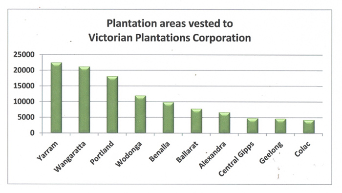
- created an estate of 113,209 ha composed of 105,964 ha of softwood and 7,245 ha of hardwood plantations – the area by region is shown in the figure below.
- the estate incorporated productive plantations based on best practice.
- the resource supported new competitive mills in all major plantation regions with consequent social, job creation and economic benefits.
- the estate was ultimately sold to private investors for an attractive price of $550 million under conditions ensuring the continuation of the plantations. The Government also received $68 million in dividends from its state owned enterprise, Victorian Plantations Corporation.
- the plantation business provided sustainable log supplies for regionally based competitive processing sector well positioned for future prosperity in a timber hungry market.
1851 to 1940s/50s
New Conifer Nursery at Creswick – the new nursery employing larger scale “production line” techniques was a significant advance, successfully producing large numbers of hardy seedlings at low cost thus avoiding the undesirable previous practice of broadcast seeding. Continued seedling losses from grazing animals required expensive fencing of newly planted areas. The large cost adversely affected the rate of plantation expansion.
Fire Losses – about 4,400ha of FCV softwood plantation was destroyed by the fires, principally at Narbethong, Noojee and Bright.
Need for Plantations Timber – the post-war reconstruction boom resulted in tight supplies of timber for housing, and demonstrated the need for timber from plantations in the future to supplement the supply of hardwood timber from native forests.
1940s/50s to 1967
Sirex - the first confirmed detection of Sirex wood wasp in Victoria and mainland Australia.
FCV Requests Commonwealth Funding – the FCV in its evidence to the Commonwealth Government’s Distribution of Population Committee indicated there was derelict land available in Victoria which was suitable for pine plantations. It requested £200,000 per year from the Commonwealth Government to establish plantations on the land
Assistance for Private Plantations – private plantations were an integral component of the overall timber supply plan. Accordingly, the Softwood Plantations Loan Scheme was created to assist the establishment of plantations on private land
The FCV also emphasised the importance of being able to fund preferred cultural operations to ensure optimal growth and sawlog production
The AFC also requested the Commonwealth Government provide tax concessions to encourage private plantations and the Commonwealth and State Governments defer estate and probate duties to encourage private plantations. The Commonwealth Government provided $18 million over the five year period for the States to plant a total of 100,000 ha.
1967 to 1984
1970’s Aerial Spraying – spraying became a preferred practice for controlling weeds during plantation establishment. Initial weedicides included 2,4,5 – T (2,4,5 – Trichloropyrimidine) and 2,4 – D (2,4 Dicholrophenoxyacetic acid) which were chemicals that had attracted wide spread attention because of association with defects in new born from their use in Vietnam. These were subsequently replaced with other weedicides.
Later in the decade aerially-applied chemicals were also used to control Dothistroma, a needle blight fungus. Chemical use became a rallying issue for opposition from impacted communities across the State. Plantations became more visible and impacted more communities as the program expanded.
1970’s Environmental Studies – FCV commenced major studies into environmental aspects of plantations in North East Victoria. These studies represented a proactive response to growing questions about the environmental effects of plantations. One component included comprehensive surveys of the biology of existing plantations and covered plants, mammals, birds, insects and water biota. Another component was the study of the impact of plantations on the hydrology. Three catchments were monitored before one of the catchments was converted to plantation. This was a significant long term study into the hydrology of pine plantations. The hydrology was again measured when the second crop was established over 30 years later. Also the opportunity arose to measure the impact of fire when the area was burnt by wildfire in 2006.
The debates foreshadowed the changing times of the 1970’s for plantations and native forests.
Victoria’s area target for the five years was increased to 26,000 ha which was exceeded.
Victoria’s public plantation estate was 83,000 ha by 1973.
- support for the continued plantation program but at a reduced scale.
- clearing native forests for plantations should cease.
- other states should copy Victoria's Land Conservation Council for independent recommendations on public land use, incorporating public expectations with respect to contemporary conservation.
- FCV was commended for high environmental standards and planting on purchased private land.
- there was a need to improve financial returns from funds provided under the agreements.
- Victoria was performing well and should continue to be assisted under the agreements.
The LCC North East Victoria plantations recommendations became an active regional issue in the State election campaign.
Environmentalists, local community groups and farmers were opposed at different times for a number of reasons including “Too Many Pines” and “Pine Free Zone” campaigns, potential environmental effects, need to cease clearing native forests for plantations and loss of agricultural land to plantations.
1984 to 1992
- plantation management objectives included optimising financial returns, ensuring timber for a competitive integrated industry and encouraging establishment of private softwood plantations.
- TIS provided longer supply contracts and agreements ratified by legislation based on major new investment in processing mills.
- TIS also foreshowed the phasing out of native forest clearing for plantations.
- Plantation area target was set at 125,000 ha to be established by 1996 to provide for contracted volumes in future and support ongoing investment in a competitive processing sector. The estate reached 113,209 ha in 1993 when it was vested in the Government-owned Victorian Plantations Corporation (VPC).
Long-term Supply to Victree – the log supply supported a new sawmill built at Colac. The company also had its own modest plantation program
Aerial Spraying Banned – Premier Joan Kirner banned aerial spraying of Velpar weedicide in Stanley plantation.
- the TIS plantation target of 125,000 ha was reduced to 120,000 ha.
- the study recommended that plantation expansion should be private sector enterprise.
Merchant banker CS First Boston valued the plantations at $300 million but noted that what was being sold and how it was sold are major determinants of the sale price.
Planning Controls - to help small owners State planning controls are amended to allow small plantations (40 ha or less) to be established without obtaining a planning permit.
1992 to 1998
Commercialisation – the plantations were vested in the newly formed VPC as the first step in exiting the business. The Government sought to commercialise the business before sale to maximise the price, and ensure the business was in an appropriate state to support a competitive processing sector in the future. The task under VPC required the following:
- improve the financial return.
- provide a record of financial accounts consistent with Australian Accounting Standards.
- replace government licences and agreements with commercial contracts.
- establish legal plantation boundaries.
- amend law to provide for industrial fire brigade.
Valuation - the VG valued the plantations when they were vested which was the VPC’s starting point. VPC reported a valuation $202 million at the end of its first year of business in its 1994 Annual Report.
- 1994 Benalla Particle Board Mill - pulpwood for a new particle board plant at Benalla provided an outlet for surplus from Benalla plantations.
- 1996 Wangaratta Medium Density Fibreboard (MDF) mill - pulpwood for a new MDF plant at Wangaratta provided another outlet for surplus from North East plantations.
- 1997 Softwood Plantation Exporters - VPC partnered with its customers (AKD Softwoods and Victree) to export woodchips from sawmill chips and plantation pulpwood to provide outlet for Western plantations.